Welcome to Planning Methods

Matt Bhagat-Conway
TA: Yuhua Wang

About me

  • Assistant Professor of City and Regional Planning
  • Consultant at the Odum Institute
  • Research interest in transportation
  • Director of transportation specialization
  • Pronouns: he/him

About me

  • From Palo Alto, CA
  • Undergraduate degree from Foothill College and UC Santa Barbara, MA and PhD from Arizona State, all in geography
  • Live in southwest Durham, bike + bus to get to UNC
    • I have never commuted regularly by car, was car-free until 2021
  • Work experience: Fellow in the Data Science for Social Good program, software developer and project manager at a public transport planning consulting firm

A white and brown pit bull in purple pajamas

Dolce

A white and brown pit bull with snow on her nose, in a snowy yard

A rectangular oak table

A round side table with three angular legs

A round cherry dining table with three legs, in a breakfast nook, with tea on it

My research

  • How to make alternatives to automobility relatively more attractive
  • Interactions between land use and transportation
  • Computational focus

My research: transit planning

  • Develop algorithms to calculate transit travel times under different scenarios
  • Account for fares in transit routing
  • Evaluate use of automated scheduling for transit operations

My research: rush hours

  • Rush hours are spreading out after the pandemic
  • Peak-hour travel demand is lower even as total travel demand has bounced back

Image showing temporal pattern of traffic demand, demonstrating that demand has spread after the pandemic

Changes in occupancy and traffic flow, pre-pandemic vs. post-lockdown

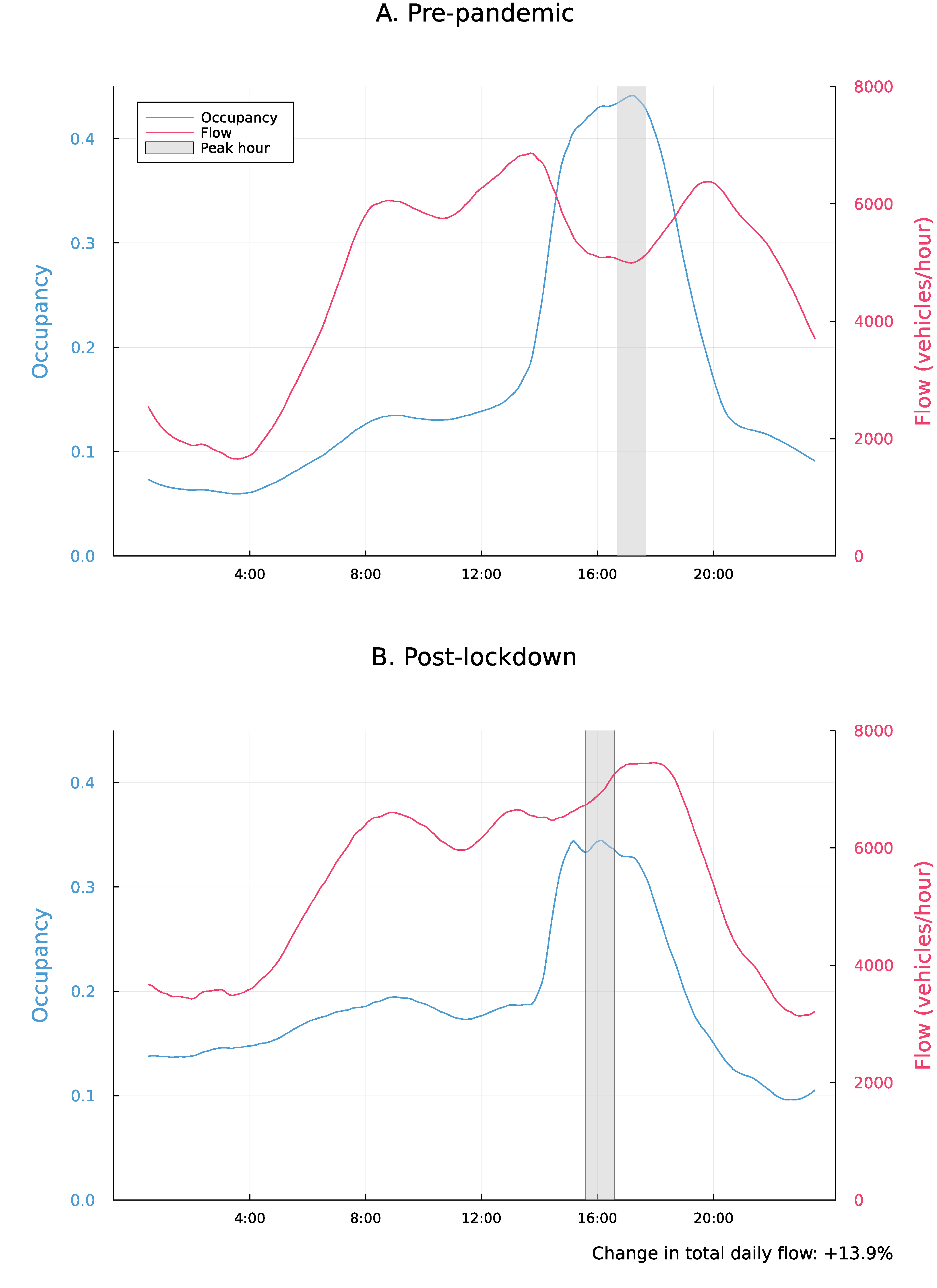
Bhagat-Conway and Zhang (2023)
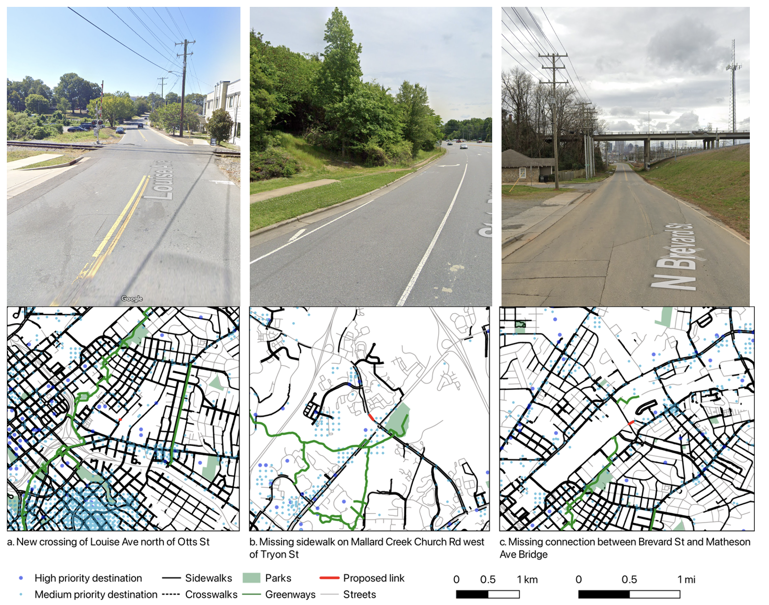
About Planning Methods

  • Lots of methods used in planning
  • In this class we touch on the common ones
  • We’re boldly going where no one has gone before well beyond statistics
  • The first part of the class is things all planners should know; the second part is methods from subfields that you should have a general understanding of
    • Not 100% even split

Emergency preparedness

  • If we hear a fire alarm or Alert Carolina emergency notification, we will implement one of the following procedures
    • Evacuation
    • Shelter-in-place
    • Secure-in-place
  • If you receive an Alert Carolina emergency notification that I have not noticed, please interrupt the class to make us aware of it
  • There is a fire extinguisher in the hallway to the right

Evacuation

  • Primarily used if there is a fire
  • There are three exits from this building
  • Our primary exit is the east stairs outside the classroom—turn right from the classroom, go to the end of the hall around the corner, go down one flight and into the lobby to exit, or down two flights and make a U-turn then a left turn
  • Our secondary exit is the stairs at the far end of the building—turn left out of the classroom, walk to the end of the hall, left then right. Can exit through the lobby on floor two or through a door at the bottom of the stairs (turn left from the staircase)
  • If you think you may need help with evacuation, send me an email so I am aware

Shelter in place

  • Primarily used for severe weather
  • Our primary shelter in place location is the first floor hallway (one level below the lobby)
  • Take the stairs next to the classroom down two flights

Emergency procedures: secure in place

  • Primarily used for an active attacker on campus
  • We will lock the door to the classroom
  • In this situation, we will also lower the shades, turn off the lights, and speak only in low voices

Emergency procedures: medical emergency

  • If someone has a medical emergency, we will call 911
  • I will send a volunteer to the front entrance of the building to direct first responders when they arrive
  • If you have a medical condition you’d like me to be aware of in the event of an emergency feel free to reach out
  • There is a defribrillator and bleeding control kit on the first floor of the building (the floor below the main lobby), in the hallway towards the middle of the building, directly across from the gym entrance

Structure of the class

  • Two lectures weekly @ 10:35
  • Most classes have assigned readings; please read before class
  • Office hours
    • MWBC: Mondays 1-2:30, Thursday 9:30-10:50, New East 320
    • YW: TBD

Attendance

  • Attendance is 15% of your grade
  • You get two free unexcused absences; additional unexcused absences will reduce your attendance grade
  • I am happy to excuse absences for illness, family emergencies, conferences, work events, etc., just send me an email
  • To take attendance efficiently with such a large class, we will use the UNC Check In app.
    • You need to check in from in the classroom within the first ten minutes of class.
  • I will start taking attendance on Wednesday

Access UNC Check-In

Homework

  • Eight individual assignments/problem sets
    • Each worth 5 points
  • One group project worth 10 points
  • One MP (master’s project) short proposal (5 points)
  • Midterm exam, open book, online, multiple choice (10 points)
  • Final exam, closed book, in person (Dec 11, 12-3), multiple choice (20 points)
  • CITI human subject research training (0 points but required to pass)
  • Assignments always due on Wednesdays, generally one assignment per week

Textbooks

  • All textbooks available free from UNC Library
    • Applied research methods in urban and regional planning, by Yanmei Li and Sumei Zhang
    • Real estate development: principles and process, 5th ed., by Mike E. Miles, Laurence M. Netherton, and Adrienne Schmitz
    • City economics, by Brendan O’Flaherty
    • The effect, by Nick Huntington-Klein
    • Collecting, managing, and assessing data using sample surveys, by Peter Stopher

Canvas

  • Available on Canvas
    • Syllabus
    • Shared calendar
    • Lecture materials
    • Assignments (under Modules)
    • Class recordings (Panopto tab)
      • Not a substitute for attendance

Group work

  • There is one group project
  • For individual projects, please work together
  • Make sure the work you turn in is your own, but it is encouraged to work together as you’re doing them
  • Only exceptions: midterm and final

Late work

  • One free late assignment, up to one week late with no penalty, just let me know you want to use your free late assignment
  • Other late assignments: 10% penalty per day up to five days, then not accepted
  • Cannot be late: group project, midterm, MP assignment
  • Canvas shows due date as 11:59 PM, I will accept assignments as “on time” until 8 AM the next day.
  • Let me know if personal circumstances arise that prevent turning things in on time, etc.

AI usage policy

  • ChatGPT/AI tools can be useful but can also hurt learning
  • OK to use AI
    • Finding more details on class topics
      • Though it often gives wrong answers in my experience
    • Having a “conversation” to help you understand something
      • AI is most useful for answering questions you already know the answer to
  • Not OK to use AI
    • Asking for answers to homework/exam questions
    • Copying and pasting from ChatGPT into anything you turn in (except grammar corrections)

What we’ll cover

  • Research skills
  • Statistics
  • Qualitative methods
  • Survey methods
  • Focus groups and interviews
  • Census data sources
  • Data visualization
  • Demographic projections
  • Development finance
  • Transportation modeling
  • Urban economics
  • Economic impact assessment

History of Planning Methods

  • Methods fall into two categories
    • Quantitative (using numbers)
    • Qualitative (not using solely numbers)
  • Much research uses both

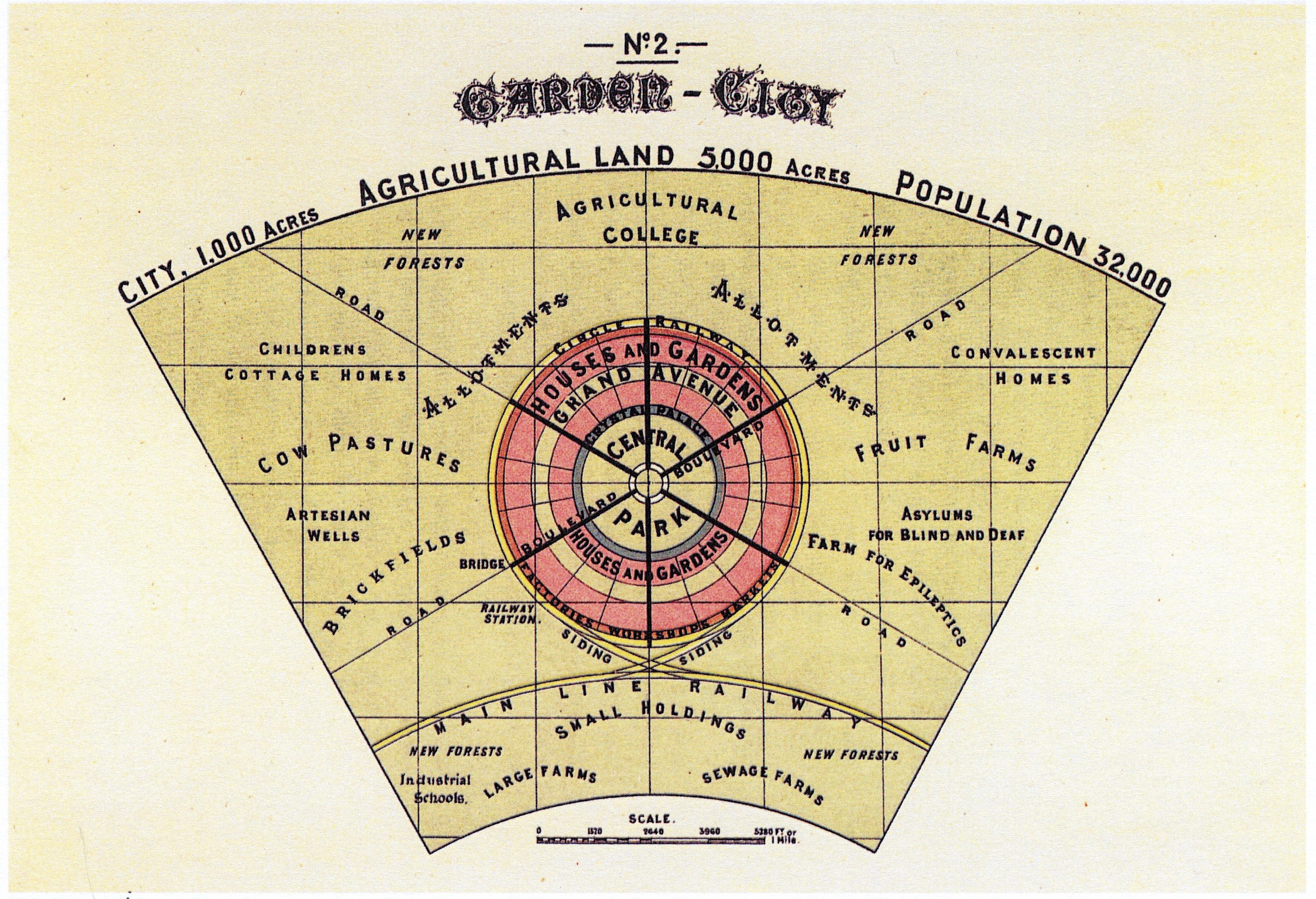
A brief, selective history

  • Planning was historically (primarily) qualitative and theory driven

Concentric model of a garden city, with a park at the core and commercial around the edge

Ebenezer Howard’s Garden City (Howard 1898)

Mid-rise and high-rise buildings in a parklike setting

Le Corbusier’s Ville contemporaine de trois millions d’habitants (© Fondation Le Corbusier)

Quantitative methods in planning: John Snow (1854)

Map of central London, with dots showing locations of cholera cases concentrated around the Broad Street pump

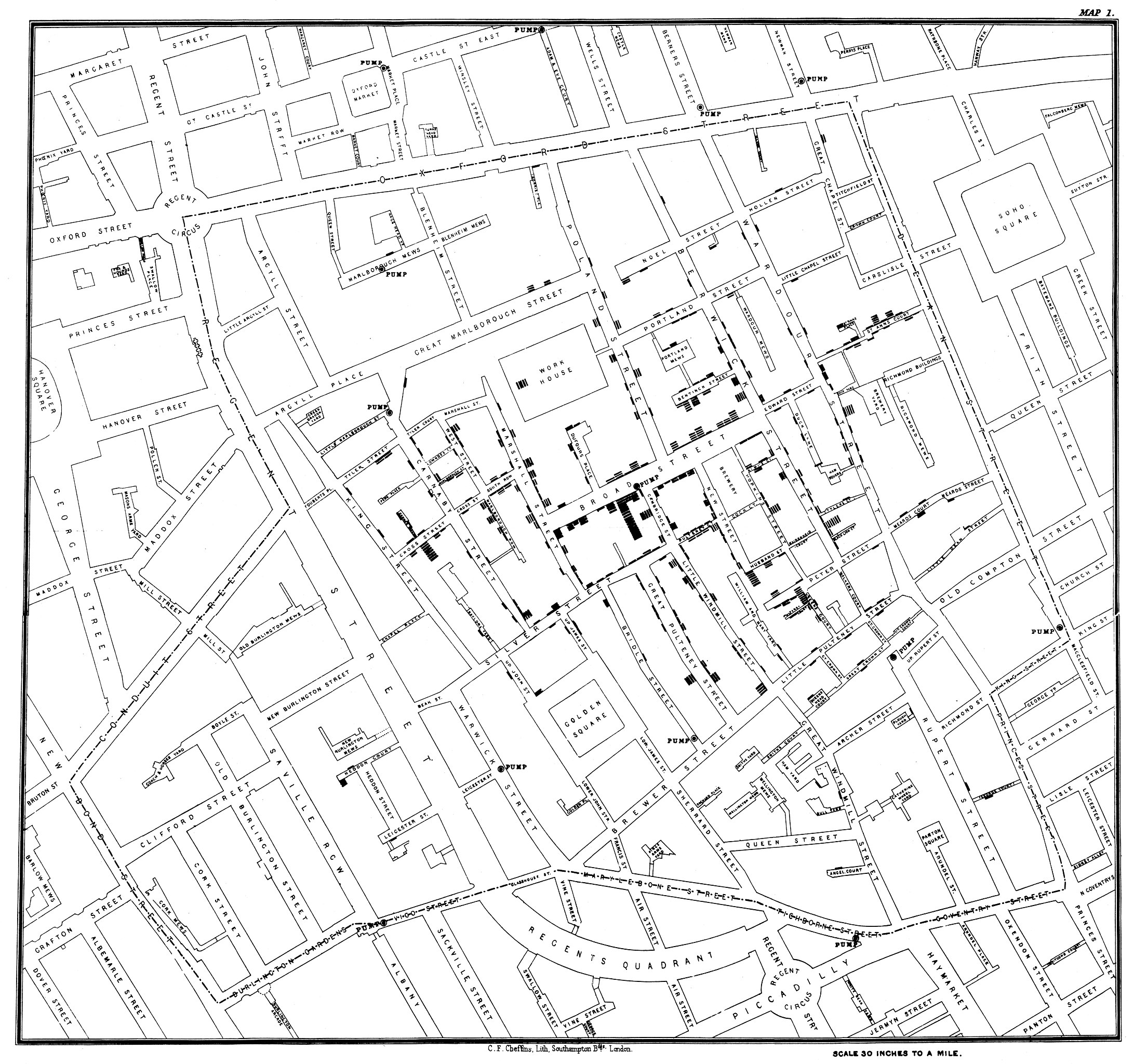
John Snow’s map of cholera cases around the Broad Street Pump (Snow 1854)

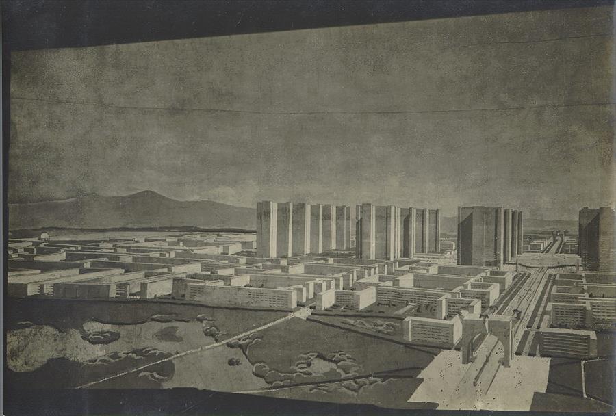
Burnham Chicago plan

  • Some descriptive statistics
    • 590 people/acre of park
    • 95% of traffic into Chicago carried by freight railroads

Map of Chicago, showing existing and proposed parks

Parks plan from Burham’s 1909 Plan of Chicago (Burnham and Bennett 1909)

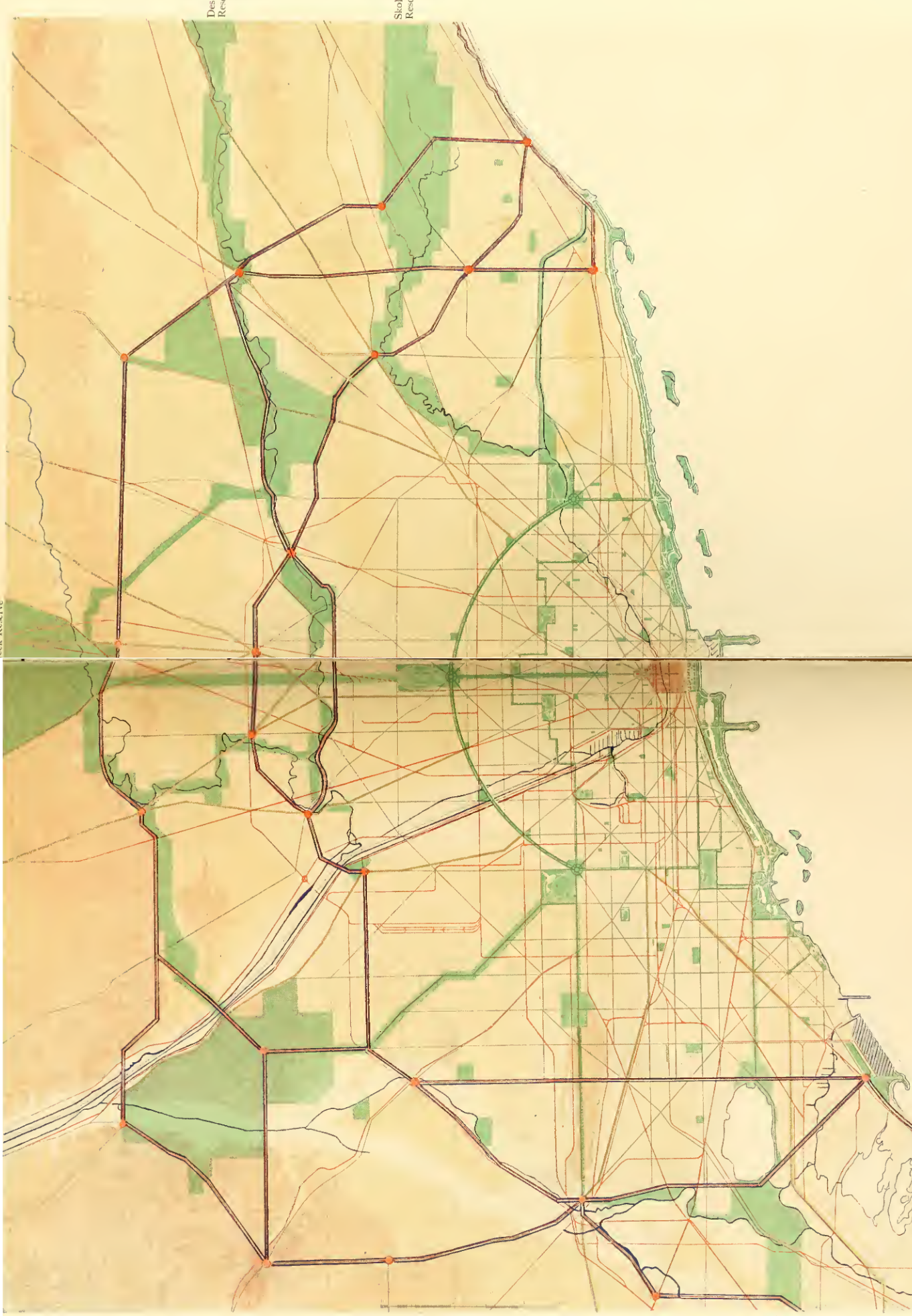
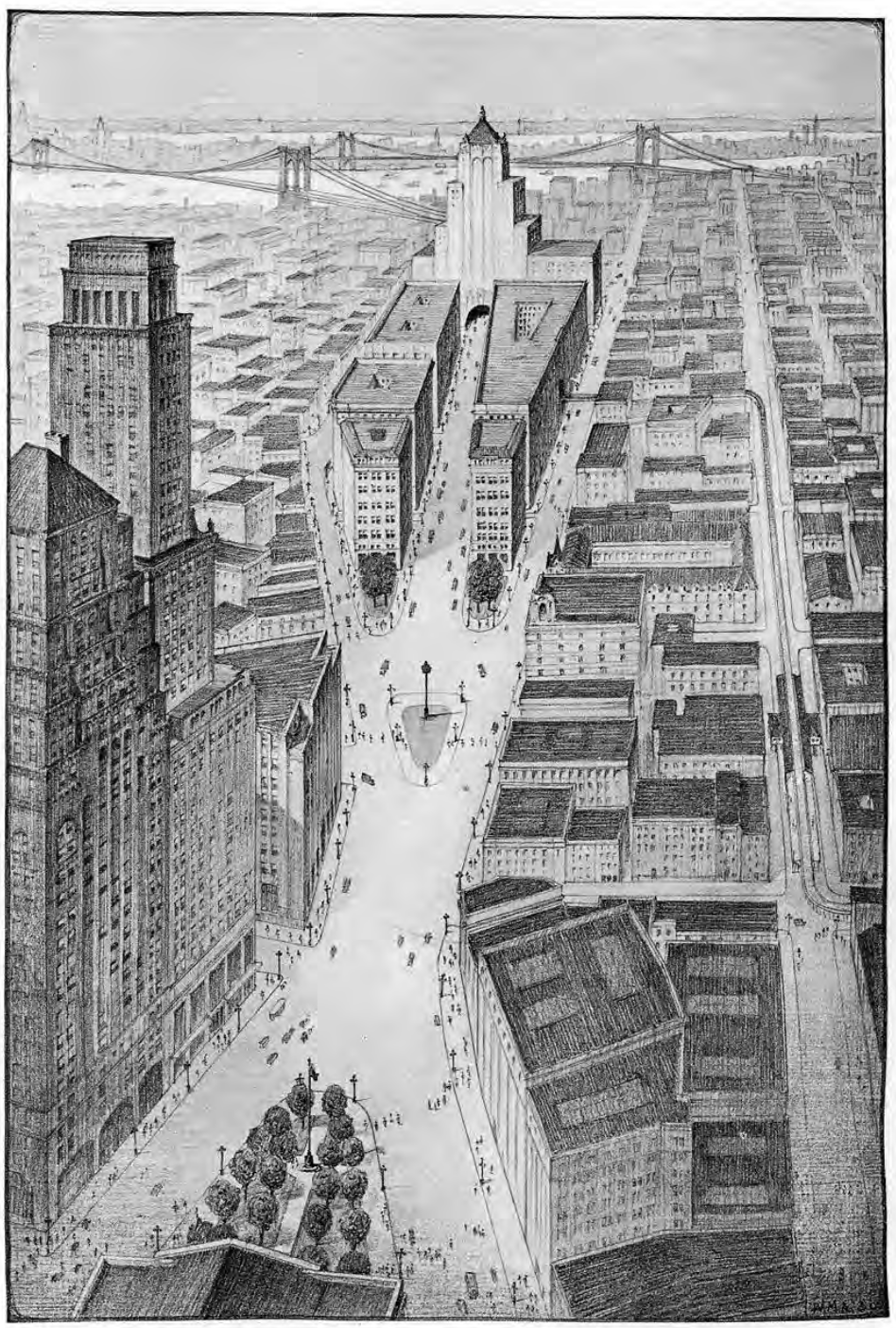
The First Plan of the New York region (1929)

  • Plan preceded by an eight-volume survey and analysis of existing conditions
  • Information such as total freight volumes at New York harbor, nighttime and daytime populations of Manhattan, and number of motor vehicles

A large open pedestrian area proposed for Brooklyn

Proposed plaza from the First Regional Plan (Committee on Regional Plan of New York and Its Environs 1929)

Computers enter the scene: the Chicago Area Transportation Study

  • In the 1950s, computers started being used in planning
  • Chicago Area Transportation Study collated thousands of responses with a computer (Plummer, n.d.)
  • Travel demand forecasts were made using one of the first four-step demand models, a type of model still used today

The situation today

  • Most planners use a mix of qualitative and quantitative methods
  • Almost every planning project will entail some analysis of Census or other data
  • Interviews, focus groups, etc. are common as well
  • Particularly in transportation, statistical models are ubiquitous

What is research?

  • Systematic
  • Generalizable
  • Collaborative
  • Incremental
  • Has real-world implications

What is a research question?

  • A question that a research project sets out to answer
  • Clear and focused
  • Not too broad or narrow
  • Not trivial to answer
  • Something that we have the resources to figure out the answer to
  • Something we don’t already know the answer to
  • Something where the answer has real-world implications

Adapted in part from Monash University Library (n.d.)

Brainstorm with a partner: interesting research questions in urban planning

What do you think is the answer to these questions?

  • Why?

How would we answer those research questions?

  • What data would you use or acquire?
  • What methods would you use?

What are the policy implications of the answers to these questions?

For Wednesday: Install Zotero

https://zotero.org

References

Bhagat-Conway, Matthew Wigginton, and Sam Zhang. 2023. “Rush Hour-and-a-Half: Traffic Is Spreading Out Post-Lockdown.” PLoS One.
Burnham, Daniel H, and Edward H. Bennett. 1909. Plan of Chicago. Edited by Charles Moore. The Commercial Club. http://livinghistoryofillinois.com/pdf_files/Plan%20of%20Chicago%20by%20Daniel%20H%20Burnham.pdf.
Committee on Regional Plan of New York and Its Environs. 1929. Regional Plan of New York and Its Environs. Wm. F. Fell Co. https://rpa.org/work/reports/regional-plan-of-new-york-and-its-environs.
Howard, Ebenezer. 1898. To-Morrow: A Peaceful Path to Real Reform. Swan Sonnenschein & Co., Ltd.
Monash University Library. n.d. “Developing Research Questions.” Library. Accessed August 19, 2023. https://www.monash.edu/library/help/assignments-research/developing-research-questions.
Plummer, Andrew V. n.d. The Chicago Area Transportation Study.
Snow, John. 1854. On the Mode of Communication of Cholera. C. F. Cheffins.